Road Closed

every place Roy takes me to we can’t get through because of SNOW!  Today was no different, Glacier National Park Road to the Sun. https://www.nps.gov/glac/index.htm

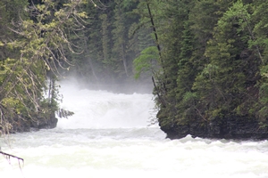
 We drove to the Avalanche Campground, I was amazed at the amount of people in the park.  We got away from the crowds by going down a dirt road at the head of McDonald Lake.  Here’s a picture of some rapids from the one lane bridge on that road.

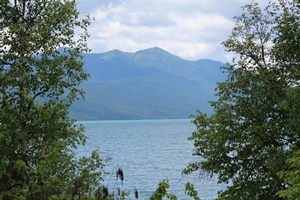
 This is the view of the lake from the dirt road.

The water falls were full and it was a nice cool day.  On tne way home I had to stop at a few gift stores, SHOPPING!  I got a few t-shirts, stopped at a roadside stand bought some cherry jelly.  I saw a wolf and bear rug with my own eyes.  I now know they do exist. 

Tomorrow is a cleaning day and Roy gets a Wallyworld day, then onto Canada.

Not a Duck

although I feel like one.  We got to the rv park after following the gps through town, no dirt roads this time.  The skies opened up at least it wasn’t snow YET!  So I was impressed that all I had to do was unlock the door and step inside.  The outside was a little more intense with sewer, water, and unhooking.  Lesson learned there are draw backs to both, when it’s raining you will get wet.

http://www.realty-northwest.com/exploringmontana/thompson-pass.htm
The drive over was amazing, the link above tells more about the drive.  The Spragpole restaurant in Murray Idaho was closed so no lunch there.  We did see a lot of dredge trailings next to the road and it looks like they are still doing some mining.  The top of the pass is 6814 with lots of hiking trails.

Today we are headed to Glacier National Park we can drive 15.5 miles in from the west, then we might drive around the park and do the 12 miles on the other side.

The Climb Or

the long and winding roads.  Coming up out of White Bird Idaho it seemed like one constant assent.  I for one am scared of heights but when I can look the views are amazing.

Monday night we stopped just short of Coeur d’Alene Idaho in Worley found a cheap parking lot with electric.  We drove through small town America even came across Moscow, but did not see the Kremlin. Stopped at the Nez Perce Indian Museum interesting band of indians.  All through this area we’ve travelled in Idaho you will see the English word below the Sahaptian word.  People who know me know I slaughter languages other then english so I’m keeping the pronunciation to myself.  For more info on the Nez Perce check this out.  https://en.m.wikipedia.org/wiki/Nez_Perce_people

On to Montana today.

Sunday Funday

Got up and out early wanted to drive down to Hells Canyon Recreation area and hopefully catch some animals.  The road over is 17 miles of gravel with switchbacks, hairpins, and a 16% grade.  That in itself is insane add to the fact that it is also open range and single lane in spots.  This road crosses the divide between the Salmon and Snake rivers, it is also the only road into Hells Canyon from northern Idaho.

Pittsburg Saddle is the high point at 4291 you climb 2800 feet from the Salmon river side then drop 3000 feet down to the Snake river side.  The views were amazing. Once on the other side down by Pittsburg Landing the water was much calmer.   Then we decided to climb back up because there is only one way out and that’s up and over. Good article on the road and landing. http://billingsgazette.com/lifestyles/recreation/road-accesses-magnificent-hells-canyon/article_7b0ceec1-be74-58d7-a614-6b44e46762c3.html

Info on the canyon

https://www.nationalforests.org/our-forests/find-a-forest/hells-canyon-national-recreation-area

Did this all before noon, grabbed lunch then went for another drive this time old 95.  This road also had switchbacks, hairpins, and no guardrails in spaces.  I was able to take a picture of the new road from the old road. I was scared because of the curves.  Here’s info on the summit https://visitidaho.org/things-to-do/natural-attractions/whitebird-hill-summit/  It was very pretty up here.  We headed to Grangeville to get gas and come home on the new 95 so much easier.  Stop at a store that had huckleberry ice cream and I found Roy’s been holding out on me, he has his own seasoning, so I also bought some.

Full day of driving a few deer lots of cows and many curves.  Headed to Coeur d’Alene.

Obese Idaho Wingless Magpie

The story behind magpies occurred last year we had just left Nevada on the trip we saw a cool bird.  I snapped a picture of it and sent it to my photo/bird guru, she told me it was a magpie. These birds are usually black with some white on the wings. 

Since then any where we go we see at least one.  So now that you have the background, I will tell you the story.

It all started Sunday morning June 11th, during my morning photo walk.  I see movement on the hill it’s black looks low to the ground slow moving.  It has to be a cat!  I zoomed in snapped the picture looked at it turned out to be a black and white cow. 

Roy saved me the embrassment of being excited and bummed about shooting the cow.  This is how I discovered the ‘Obese Idaho Wingless Magpie’.

MY STORY AND I’M STICKING TO IT!

BRRRRRRRRR!

Driving in the mountains today was down to 39 degrees, it was cloudy and rainy on and off today.  The only wildlife on the drive today was one road kill raccoon.  I didn’t see wildlife until we got our camp set up, then across the swollen Salmon river we saw three young deer.  I got pictures.

Driving up ID-55 we saw three waterfalls and numerous raging rapids.  I thought this area would be a good place to try white water rafting but the water is way too rough.  The lady who checked us in said the snake river is a little calmer as it is wider.  This river is rough because of all the snow melt coming down from the mountains.  It was funny we had to use pull outs a couple of times because in Idaho if you have more than 3 cars behind you use designated pull outs.

We stopped twice on the way up, once to take pictures of the rapids, then to eat in the car.  We stopped in front of a field of cows this one brown cow would not let her eyes off of Roy.

Tomorrow we are going looking for wildlife and taking a scenic drive into Hells Canyon, via Pittsburg Landing.  The road is 17 miles of single lane gravel road, with turn outs.

We are in White Bird for two nights then to Coeur d’Alene for one night.

Mini Road Trìp – June 9th

Today Lenny, Roy and I set out for the water, some food and finally some caches.  On this trip for my photos I would like to include more landscapes, also my video will feature more of what we are doing.  That said.

We picked up our tour guide at 9am and headed east towards Twin Falls Idaho looking for 1000 Springs Tours in Hagerman Idaho.  I had talked to Captain John on the phone and asked for the ole farts discount, which he promptly gave after lhao.  So in introducing myself I ask if he was the Captain, nope I’m Barnacle Bob.  I knew we were in good hands until on the way back we ran over a log, that had rolled into the path of the boat, dang Barnacle Bob’s driving.  Fear not Captain John over took Barnacle Bob and saved the day.  The tour was on a house boat and included a buffet, reminded me of the midwest. It’s just a two way river street up back and halfway up again, even Barnacle Bob didn’t get lost.  The cruise was amazing and I think I got some good pictures.  I promise this weekend you will have some pictures.  If you are anywhere near Boise you need to head out and take the tour.  More info on this small family owned business. http://www.1000springs.com The waterfalls were full and saw quite a few blue herons, white pelicans, and western grebes.  The grebes are diving birds very camera shy but I think I captured one or two.

On the way home we stopped for an earthcache and a true 1/1 cache.  We had an enjoyable day that was finished off with a trip to Wallyworld.  I was having withdrawals, not really had to restock the fridge.  Headed up to White Bird Idaho on Saturday for another two days.

Almost to the Day Ten Years Ago

I was in Boise joining the Army now I’m camping on a Military base in Boise.  Funny the paths life takes you.   I can’t believe it’s been ten years since I made a decision to change mine and Roy’s life.  I am glad I had the chance to serve my country and meet some amazing people along the way.

Speaking of meeting people we had dinner with Lenny and I was able to see May’s GCC geocoin and the blue indian chief headdress coin thank you Lenny.  Tomorrow we are going on a river boat cruise with Lenny should be fun.

The drive over today was raining and winding and we are here until Saturday morning.  I will try and post pictures tomorrow.

Deer

June 6th travel day 1 night stopover in Klamath Falls Oregon, free parking lot no hook-ups but boondocking is ok.  Driving up we saw 3 young bucks ran right in front of us, cool.  June 7th another travel day and 1 night stop over in Burns Ore, tomorrow we will rest our weary heads for two nights in Meridian ID to see fellow geocoin collector and cacher Lenny.

We did take the road less travelled today and I learned a valuable lesson.  Lesson learned was take a paper map with you when using GPS car navigater. We are driving along on a paved road and here in 1000 feet take the next right, we get there and it’s a dirt road.  So we pull out the map and continue down the paved road.  I guess we are old school.

The place here (Burns RV Park) is cute on the river and quite a few skeeters.  When we pulled in a newbie rvercame to chat and we were able to help her.  She had an R-Pod with a slide out no surge protecter though and she wanted to go solar, also gave her some leads on generators.

Roy and I both took a good shower so that was very refreshing the best part is they were FREE.  I hooked up the cable, Roy used the free internet, I went for a short walk.  It was short because I got bite to hell by skeeters, rubbing alchol is my friend.